Ultimate Hiking Guide to Flagstaff, Arizona – Trails, Gear & Tips

Flagstaff, Arizona, is a high-elevation paradise for hikers and outdoor adventurers. Tucked away in the cool pines of northern Arizona at an elevation of around 7,000 feet, Flagstaff is home to an exceptional variety of hiking trails that traverse ancient lava flows, alpine forests, aspen groves, and towering mountain peaks. With mild summer temperatures, vibrant fall foliage, and access to some of the most breathtaking landscapes in the Southwest, Flagstaff is a must-visit for anyone seeking unforgettable hiking experiences.

This guide will take you through the best trails in and around Flagstaff, whether you’re looking for a leisurely walk or a strenuous summit climb. You’ll also find practical information on when to visit, what to pack, safety tips, and family-friendly hikes. Let’s hit the trail!

Why Hike in Flagstaff?

Flagstaff offers something unique among Arizona’s hiking destinations: diversity in terrain and climate. While the desert dominates much of the state, Flagstaff offers cooler temperatures, towering forests, and volcanic landscapes shaped by ancient eruptions and tectonic uplift.

Here’s what makes Flagstaff a hiker’s dream:

  • Mild summer climate – Beat the Arizona heat in summer months.
  • High-elevation terrain – Great for endurance and mountain training.
  • Lush ecosystems – From ponderosa pine forests to aspen glades and alpine tundra.
  • Proximity to landmarks – Near Sedona, the Grand Canyon, and more.
  • All skill levels – Whether you’re a beginner or an expert hiker, there’s a trail for you.

Top Hiking Trails in Flagstaff

Below is a breakdown of some of Flagstaff’s most popular and scenic hiking trails, organized by difficulty level.

 Easy to Moderate Hikes

1. Buffalo Park Loop

  • Distance: 2 miles (loop)
  • Elevation Gain: Minimal
  • Trailhead: North Flagstaff
  • Highlights: Wide open meadows, San Francisco Peaks views, fitness stations


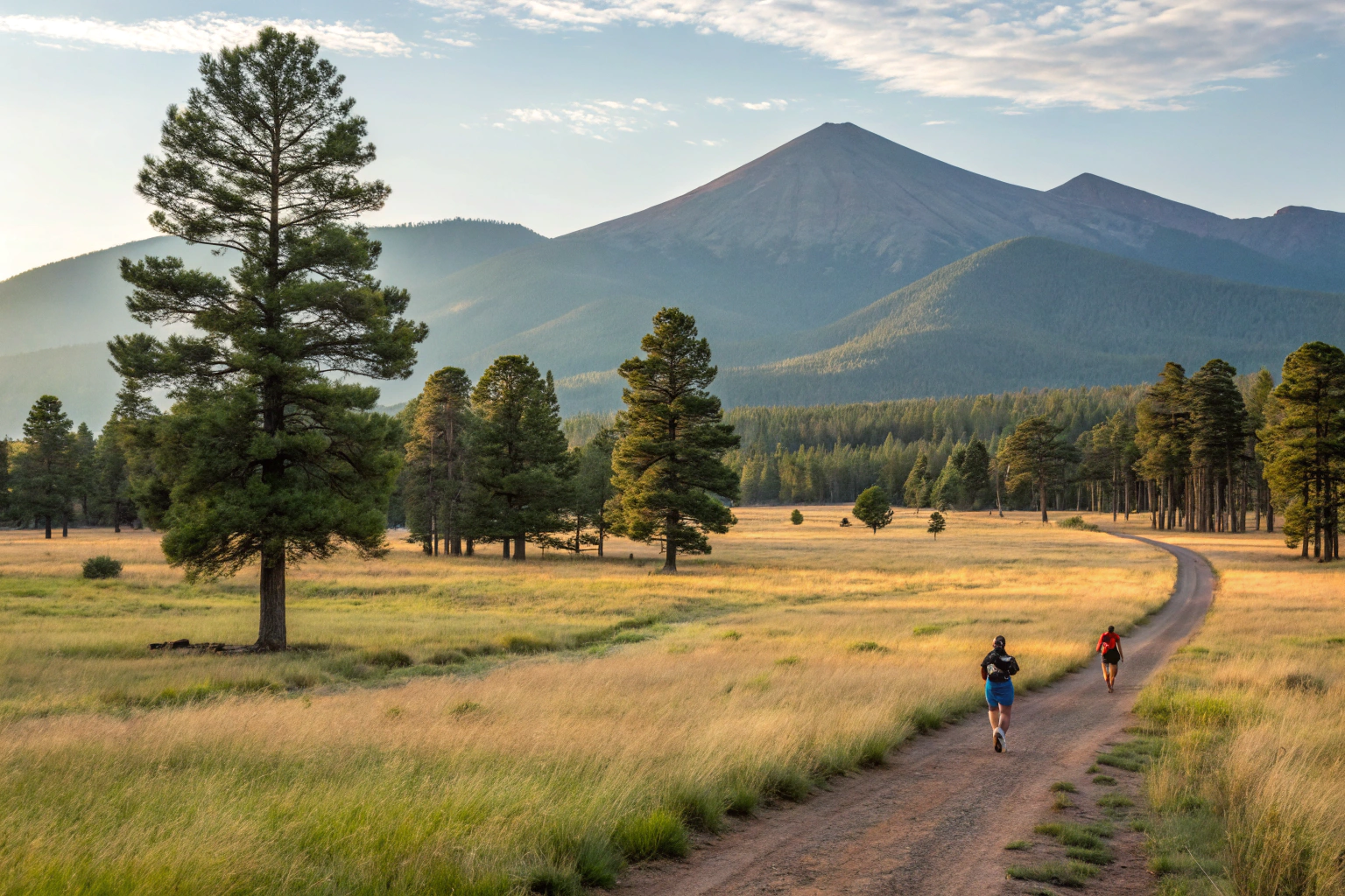
Ideal for a morning jog or a relaxing family walk, this flat gravel trail loops around the open fields of Buffalo Park. It’s a favorite for locals and offers some of the best views of the San Francisco Peaks, especially during sunrise or sunset.


2. Fatman’s Loop Trail

  • Distance: 2.5 miles (loop)
  • Elevation Gain: ~500 feet
  • Trailhead: Mount Elden Lookout Road
  • Highlights: Rock formations, wildflowers, city overlooks

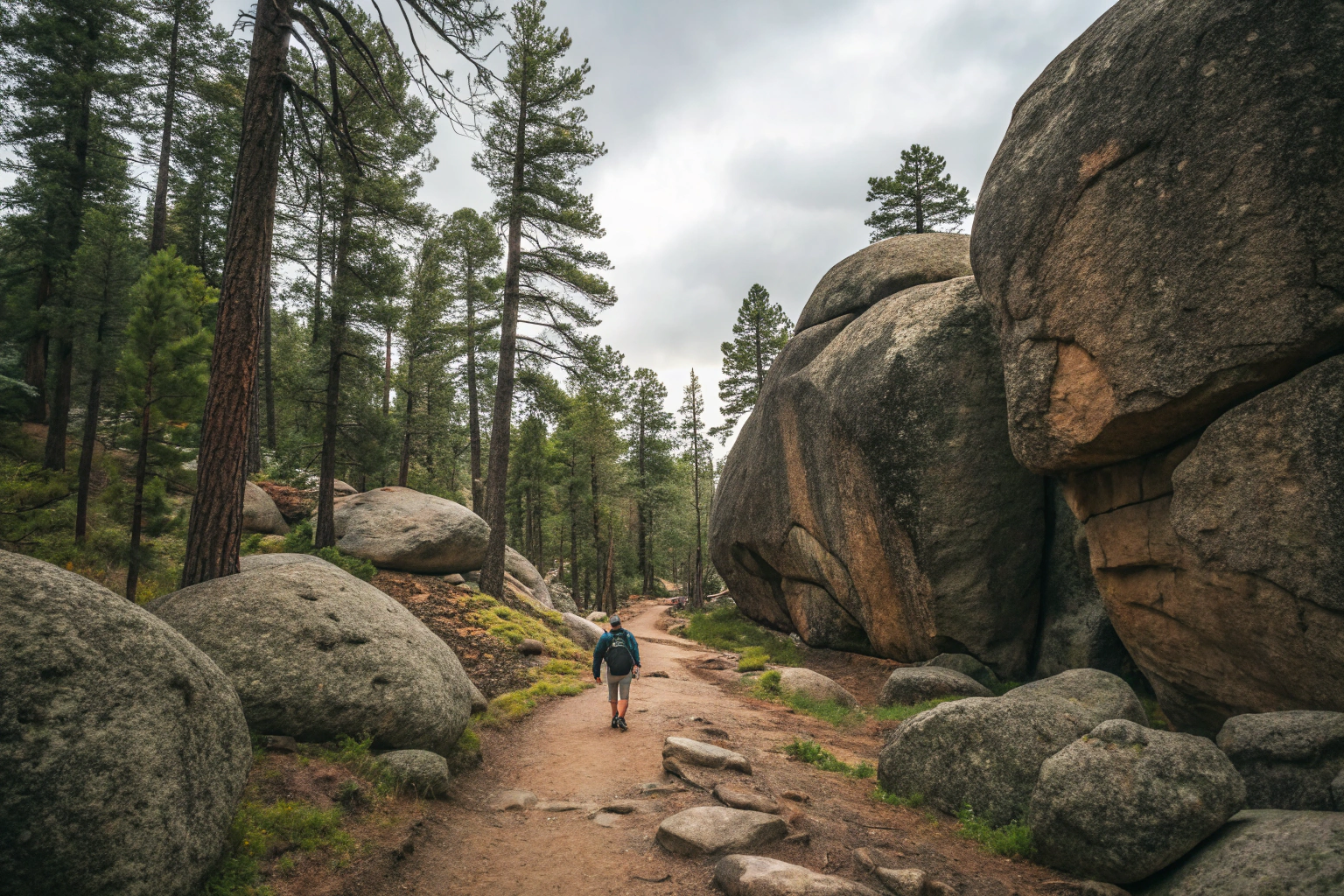
This moderately easy trail offers just the right amount of challenge. It gently ascends through ponderosa pine forest and skirts massive boulders, including a narrow rock passage known as “Fatman’s Pass.” It’s popular and well-maintained, making it a great option for beginners looking for something more adventurous.
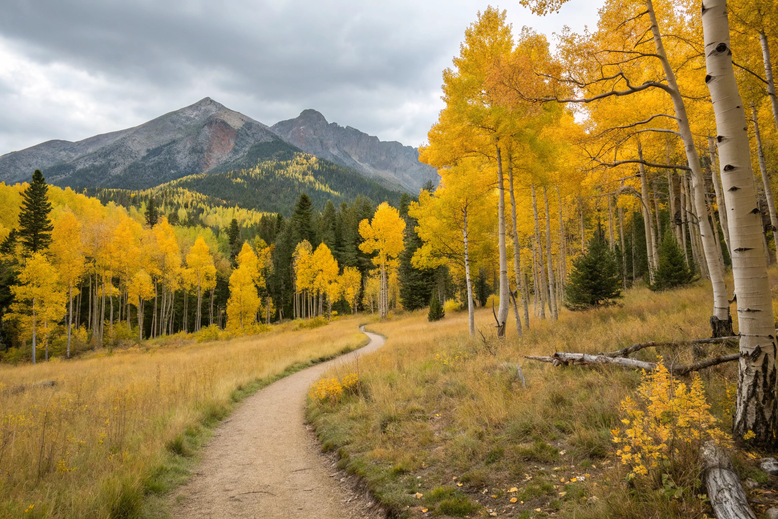

3. Kachina Trail

  • Distance: 10.4 miles (out and back)
  • Elevation Gain: ~1,800 feet
  • Trailhead: Snowbowl Road
  • Highlights: Aspen groves, meadows, views of the San Francisco Peaks

Located on the southern slopes of the San Francisco Peaks, the Kachina Trail offers stunning views and incredible scenery, particularly in the fall when the aspens turn a brilliant gold. While long, the elevation gain is gradual, making it doable for moderately fit hikers.


4. Lava River Cave

  • Distance: ~1 mile one-way (inside the cave)
  • Trailhead: Off Forest Road 245
  • Highlights: Ancient lava tube, consistently cool temperatures

If you’re looking for a unique and chilly adventure, head underground into a 700,000-year-old lava tube. The cave stays around 42°F year-round, and the rocky floor requires good shoes and multiple light sources. It’s a short hike but entirely different from the rest of Flagstaff’s offerings.

Moderate to Difficult Hikes

Humphreys Peak Trail

  • Distance: 10.4 miles (round trip)
  • Elevation Gain: 3,400 feet
  • Trailhead: Arizona Snowbowl
  • Highlights: Arizona’s highest point (12,637 ft), alpine views, volcanic ridgelines

This is Arizona’s ultimate hike. Humphreys Peak is not only the tallest point in the state but also offers sweeping views all the way to the Grand Canyon on clear days. The climb is strenuous, with steep switchbacks, high winds, and thin air, but the sense of accomplishment and scenery make it worthwhile.

Inner Basin Trail

  • Distance: 3.5 miles one way
  • Elevation Gain: ~1,200 feet
  • Trailhead: Lockett Meadow
  • Highlights: Fall foliage, volcanic terrain, stunning basin views

One of the most visually rewarding hikes in Northern Arizona. This trail begins in a quiet aspen grove and climbs into the heart of a massive ancient caldera. It’s especially beautiful in late September and early October when the aspen leaves change color.

Elden Lookout Trail

  • Distance: 5.6 miles (round trip)
  • Elevation Gain: ~2,300 feet
  • Trailhead: Mount Elden Lookout Road
  • Highlights: Panoramic views, fire tower

This steep hike ascends quickly through switchbacks to a summit with a 360-degree view of Flagstaff and surrounding volcanic fields. It’s a popular training hike due to its challenging grade and rewarding vistas.

Bear Jaw & Abineau Loop

  • Distance: 7.6 miles (loop)
  • Elevation Gain: ~2,100 feet
  • Trailhead: Forest Road 418
  • Highlights: Two scenic canyons, wildflowers, solitude

Tucked away in the northern part of the San Francisco Peaks, this loop takes hikers through two beautiful, secluded canyons. Expect wildflowers in summer and golden aspens in fall. The trail is less crowded than others, offering a more remote experience.

When to Hike

Best Times:

  • Late May to Early October – Snow-free trails and mild weather.
  • Fall (late September to mid-October) – Aspen trees light up with vibrant gold.
  • Winter (December–March) – Snowshoeing or winter hiking on lower trails.

Avoid:

  • Monsoon Season (July–August) – Afternoon storms and lightning risk on higher elevations.
  • Spring Melt (March–May) – Trails may be muddy or snow-covered at elevation.

What to Pack

Flagstaff’s elevation and rapid weather changes demand smart preparation. Always pack:

  • Water (2–3L minimum)
  • Trail snacks or lunch
  • Layers (temperature drops quickly with elevation or weather shifts)
  • Sunscreen, hat, and sunglasses
  • Trail map or GPS device/app
  • Sturdy hiking boots
  • Trekking poles (optional, useful on steep trails)
  • Headlamp/flashlight (especially for Lava River Cave)
  • First aid kit
  • Trash bag (Leave No Trace)

Wildlife, Safety, and Trail Etiquette

Flagstaff is home to diverse wildlife, including:

  • Elk
  • Mule deer
  • Coyotes
  • Black bears (rare sightings)
  • Rattlesnakes (more common in lower elevations)

Safety Tips:

  • Start hikes early to avoid storms.
  • Stay on marked trails.
  • Carry a map or download offline GPS.
  • Acclimate to the altitude if coming from lower elevations.
  • Never leave trash behind and follow Leave No Trace principles.

Family & Dog-Friendly Trails

For Kids:

  • Buffalo Park
  • Fatman’s Loop
  • Lava River Cave (for older kids who enjoy adventure)

For Dogs:

  • Dogs are allowed on most Flagstaff trails but must be leashed.
  • Carry extra water and waste bags.
  • Be cautious of hot surfaces and wildlife.

Nearby Attractions for After-Hike Fun

  • Downtown Flagstaff – Grab a bite, coffee, or local craft beer.
  • Arizona Snowbowl – Scenic gondola rides in summer.
  • Lowell Observatory – Great evening stop after a day on the trail.
  • Walnut Canyon National Monument – Hike among ancient cliff dwellings.

Final Thoughts

Flagstaff’s hiking scene is nothing short of extraordinary. With alpine summits, shaded forests, and unique volcanic terrain, it’s a destination that rewards exploration and reverence for nature. Whether you’re conquering the rocky path to Humphreys Peak or strolling under golden aspens on the Inner Basin Trail, hiking in Flagstaff is a deeply rewarding experience.

So gear up, breathe in the mountain air, and set off on your next unforgettable hike in the heart of northern Arizona. You’ll leave with not only tired legs—but a full heart and a camera roll of majestic views.

Leave a Comment

Your email address will not be published. Required fields are marked *

Scroll to Top